Friday, August 27, 2010

A real trip to an imaginary circle


North of Fairbanks, Alaska, the Dalton Highway stre4tches upwards to Prudhoe Bay, the beginning of the Alyeska, otherwise known as the Trans-Alaska Pipeline. We wouldn't get that far, but we planned to get a little north of the Arctic Circle, the imaginary line that separates the polar zone from the rest of the world.

The Dalton Highway - Alaska State Highway #11 - is largely unpaved. It's occasionally rocky, occasionally muddy, and occasionally actually paved or in the process of being paved. At one section, the by-now-familiar pilot car took us through one lane traffic. To reduce dust for the workers, a tanker sprays water on the road at various intervals. While not slippery, it does produce a fine mud mist, especially if you allow yourself to get a little too close to the vehicle in front of you, some of which were large oil tankers on their way to the Arctic. By the time we emerged onto "solid" road, my beautiful burgundy car was two-toned, with the bottom half a lovely mottled tan.

But before we knew it, we were at the Yukon River Bridge. We'd had fun following the Pipeline, as it sometimes got extremely close to the roadway and then disappear into the spruce trees. On hills, we could see the brown-gray road and the silver pipe ahead. In some spots, the pipeline went underground, under the road, and even under rivers. At the Yukon, it joined our bridge and stretched over the mighty river. At the other side, a Visitor Center welcomed us, for which we had to drive under the pipeline!

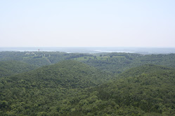
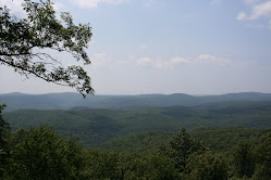
A few miles further took us to the strange land of Finger Mountain. Large piles of volcanic granite made formations - one like a 40-foot high pointer finger beckoning "come here" to those who drive up themountainside. Few trees grew on the tundra that surrounded the mountain. Small shrubs and blueberry bushes decorated the ground, some of them turning yellow and red in the sub-arctic autumn that was fast approaching. The story goes that the Fireweed plant keeps blooming to the top as the season progresses. When the tip-top blooms, winter is just around the corner. Many of the roadside plants were flowerless and it's "only" August.

And finally we reached the Arctic Circle. No, there's no line on the road at latitude 66 degrees, 33 minutes. But there is large plaque that proclaims we made it - a probable once in a lifetime crossing (well, 3 times actually, as we had to go back a few miles for our sleeping arrangements...and we had to come back this way!) It was kind of cool (literally and figuratively). We had set a goal and achieved it. No flat tires, no broken windows (yes, OK, a few scratches under that muddy exterior). But we'd reached it - "top of the world, Ma!" Now onto Coldfoot and Wiseman, the two towns above the circle that would provide us food and shelter for the next two days.

Friday, August 20, 2010

North to Alaska


The way to travel...Ferry from Washington state to Haines, Alaska. From there, drive the Haines Highway through part of British Columbia into the Yukon Territory.. (Pictured: our ferry M/V Columbia leaving port after dropping us off in Haines and a very welcoming sign.)
And onto the Alaska Highway. Built in 1942 to help get our troop equipment to Alaska to fight in the Aleutian Islands (Japan had landed on Attu), it has been rebuilt several times since (and they are still rebuilding parts of it - about 20 miles of it is dirt which we travel following a "pilot" vehicle to guide us safely through construction.). It runs from Dawson Creek in British Columbia to Fairbanks, Alaska. We're only doing a section of it on the way up, but we will drive the entire highway heading home.


Welcome to Alaska.


Monday, August 16, 2010

A Northwest Passage


Wow - we're back on land and online!
Leaving San Francisco, we crossed the Golden Gate Bridge and left it and its fog behind to enjoy the fog of the Oregon coast, which burned off by noon most days to allow us a clear view of a rose garden in Eugene, cheering on the Eugene Emeralds in an A team baseball game (they won 3-1), stopping at a lighthouse or two and the fabulous Columbia River Maritime Museum in Astoria.
Up I-5 to beautiful Bellingham, Washington to catch the ferry on the Alaska Marine Highway. With no WiFi on water, we relaxed watching the Canadian coastal mountains and its many islands float by us.
We listened and learned about northwest flora and fauna from a naturalist (a Forest Ranger from Tongass National Forest); we saw a few seals frolicking, "ooohed" at a humpback whale breeching a few hundred yards from the boat, and then, as we arrived in Haines, Alaska, we were treated to a mama brown bear teaching her two cubs how to catch salmon. What a great way to travel!

Saturday, August 7, 2010

Leaving one's heart in San Francisco

OK, so I should have planned an extra week beyond the conference in this fabulous "city by the bay". In addition to workshops on improvisation and theatre games, we managed to explore a little portion of Golden Gate Park (the Japanese Gardens and the Dahlia garden), bypassing the fairly expensive deYoung Museum, even though I would love to have seen the Impressionist exhibit; the Embarcadero (featuring a fabulous performance of "Peter Pan" combining live performance, puppetry, and CGI); Fisherman's Wharf and a sunset cruise that could not quite find the sun setting, but enjoyable nevertheless as we sailed past Alcatraz and under the fog-bound Golden Gate Bridge; and some shopping in Macy's, Bloomingdale's, and Nordstrom's. We finished up with a hike through The Presidio (a National Park at the base of the Golden Gate), stopping to visit the Disney Family Museum, an intensive exploration of the life, films, TV shows, and entertainment parks of Walt Disney which suggests it'll take 1 and 1/2 hours to explore, but you really need 2 days.
And tomorrow we head north, thinking that we do indeed need to come back, because a heart is a terrible thing to lose.

Wednesday, August 4, 2010

land formations

When one is driving across the USA, one pays attention to the divergent landscape. After the Great Plains of Iowa and parts of Nebraska and Wyoming, mountains are quite interesting. Of course, there's the patches of snow on the peaks above 10,000 feet, but along I-80, some of the most interesting formations are raised platforms of rock and sand. I have learned that the largest of these is a plateau - an area that is above the adjacent terrain on at least one side; similar is the mesa - from the Spanish for "table", it too is a flat raised area, but it is toyally surounded by lower terrain. Finally, the smallest of these is a butte - which one dictinary says is an "eroded mesa". but can be seen as a smaller version. Completely eroded buttes often result in hoodoos - tall spire like formations. Descending from the mountains into the basin of Utah, one encounters the salt flats - a flat section of land that is covered with salt from evaporated water (aren't you glad you asked?) We drove passed the most famous of these - the Bonneville Salt Flats, a section of which is used to speed test cars. The speed limit on the highway near there is 75 mph, although most folks go a bit faster. A favorite practice of the locals is to take dark rocks and stones arrranged on the white salt to make formations like hearts (better than carving on a beech tree I think) or initials or messages like "peace" or "Go Vikings" (I don't think they mean the ancient Danes, probably a local sports team).

Monday, August 2, 2010

Rocky Mountain High

We're in Utah, about 40miles from Park City (home of the Olympics), surrounded by the grassy sagebrush hills of the Rocky Mountains. We're staying in a lovely little cabin (emphasis on the little) near a stream in the quaint town of Coalsville. After dinner, we took a stroll up a country road and saw some wildlife: an osprey on his nest (didn't know they liked streams), a goldfinch (had to come to Utah to see the NJ state bird), a rainbow from a distant storm, and now, as I finish this outdoors on the picnic table, thunder and lightning from that not-so-distant storm!

Sunday, August 1, 2010

Shy Anne

We covered the entire state of Nebraska today. We made good time, traveling through its capital (Lincoln) and following the various Platte Rivers as we drove. Lunch was a Sunday Buffet at "Grandpa's" in Kearney, NE (pronounced just like the one in NJ). Very popular spot for locals, but I think we were among the youngest in the room. Nevertheless, they gave us the "senior discount" without being asked. Damn - I didn't think we looked old enough. But "all you can eat" for $10 each? I'll take the deal.
We also took a get-out-and-stretch break in Ogallala, where we found the "Mansion on the Hill" open for tours. We'd been by this home years ago on a previous trip while visiting nearby Boot Hill cemetary, but it was closed. So we took an hour to explore this brick home built in the 1870s, filled with interesting items from those years and on into the early 20th century, when the nearby river was dammed, creating a reservoir. With the time change (we're now in Rocky Mountain time, even though those peaks are not yet in evidence), we made up the visit, went way past our intended destination in Nebraska, and made it about 60 miles into Wyoming to stop for the night in Cheyenne. No camping though - it's raining and we need showers after the 90 degree temps down on the plains.